I am documenting the "how's" of how enslaved and free Africans and their descendants made lives and livelihoods, and a new city, out of the historical ecology of Manhattan island. I use two frameworks: "Black ecologies" by Justin Hosbey and J.T. Roane and a "spatial analysis of slavery" by Andrea Mosterman. In this post, I tell a short version of this project in three collages.

This first slide tells the story of the creation of New Amsterdam. The "F" on the top map, circa 1639 indicates the "quarter of the company slaves," the company being the Dutch West India Company. I learned about this place from the work of Andrea Mosterman, author of Spaces of Enslavement. The landscape of place denoted by "F" on the 1639 Vingboon Map was a Red Maple Hardwood Swamp and an Oak-Tulip Tree Forest (bottom left). The water source of the swamp was the Saw Mill, a creek named for the milling industry at the location. Enslaved Africans harvested trees and made lumber for use elsewhere in the colony including the construction of The Wall, now Wall Street, in 1653. Enslaved African built much of the infrastructure of the colony including canals shown in the 1660 Castello Map (bottom right).
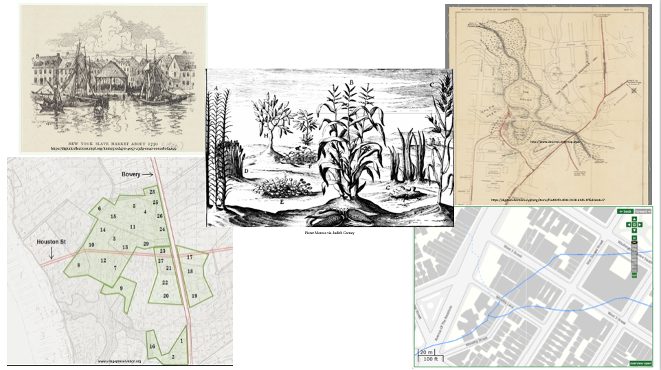
The next story in this timeline is one about water, and maize. Africans, kidnapped and enslaved, were brought to New Amsterdam under Dutch control. The British built an official slave market in 1711 (top left) on the East River waterfront. Under Dutch rule, 11 enslaved African men successfully petition for their freedom. These men are given land grants (bottom left) which carried obligations. One of them was an annual duty of agricultural products including maize which the central plant in the center image. Maize is depicted in this drawing by Pieter de Marees as one crop grown in the Gold Kingdom of Guinea in 1602. Two of the enclaves of the African diaspora in New Amsterdam are Collect Pond (top right) and Minetta Brook (bottom right).

The final part of this project shows the African diaspora's connection to trees in an increasingly built landscape. The black star on the 1660 Castello Map (top right) is the lot owned by free woman Susanna Antony Robert who planted "8 small trees." What were the species? I haven't found a record by archaeological study has found evidence of fruit trees in this area of the city. Moving ahead to the 1800s, William Brown (center top) founder the African Grove Theater in his backyard in 1816. He created a pleasure garden for African Americans; white-owned pleasure gardens were racially segregated. While there are no photos of Brown's pleasure garden, white-owned gardens are drawn and described as verdant. Brown's house was behind City Hospital which had many large trees (left right). Brown's pleasure garden might have "borrowed" the view of the hospital's canopy. Finally, Josh E. Landin was a resident of Seneca Village (bottom right). Landin sold fruit and forest trees (top right) from Lower Manhattan including the store of Black abolitionist David Ruggles.
Comments
Post a Comment
Thank you for commenting on this post!